
Topografische kaart Statesville
Interactieve kaart
Klik op de kaart om de hoogte weer te geven.
Over deze kaart
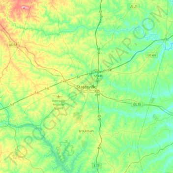
Naam: Topografische kaart Statesville, hoogte, reliëf.
Gemiddelde hoogte: 266 m
Minimale hoogte: 206 m
Maximale hoogte: 415 m
Statesville has a humid subtropical climate (Cfa) like most of the state of North Carolina, although its higher elevation leads to cooler temperatures than much of the Piedmont. Summers are generally hot and humid, with mild nights, while winters are usually cool with chilly nights and sporadic snowfall. Severe thunderstorms can be an issue during summer, with wind speeds of 60 mph and even gusts of 95 mph being recorded during these storms.