Geolokaliseren
👉 Easily get elevation data in JSON, GeoTIFF and KML formats using Elevation API
Bedankt voor het steunen van deze site ❤️
Doe een donatie

Rust jezelf uit voor je volgende avontuur:

Als Amazon-partner verdient deze site een commissie op in aanmerking komende aankopen, zonder extra kosten voor jou.

Topografische kaart Westwood

Klik op de kaart om de hoogte weer te geven.

Over deze kaart

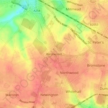
Naam: Topografische kaart Westwood, hoogte, reliëf.

Locatie: Westwood, Thanet District, Kent, England, CT10 2NU, United Kingdom (51.34117 1.37453 51.38117 1.41453)

Gemiddelde hoogte: 40 m

Minimale hoogte: 4 m

Maximale hoogte: 56 m

Andere topografische kaarten

Klik op een kaart om zijn topografie, zijn hoogte en zijn reliëf te bekijken.

Stour

United Kingdom > England > Kent > Thanet District

The source, of what is known at that point as the Great Stour, is near the village of Lenham, within a short distance of the River Len, a tributary of the Medway. The source is at a high elevation close to the North Downs escarpment. At first the river flows south east in a narrow valley parallel to the…

Gemiddelde hoogte: 7 m

Botany Bay

United Kingdom > England > Kent > Thanet District > Margate

Gemiddelde hoogte: 9 m

Rust jezelf uit voor je volgende avontuur:

🕵️Metaaldetectoren - Zoek naar verborgen schatten in de bodem
🎒Regenhoezen Rugzak - Bescherm je uitrusting tegen regen
🧭Handheld GPS - Nauwkeurige GPS-toestellen voor outdoor navigatie
🔋Outdoor Powerbanks - Laad je smartphone of GPS op in de natuur
🌞Zonne-laders - Gratis energie van de zon voor je gadgets

Als Amazon-partner verdient deze site een commissie op in aanmerking komende aankopen, zonder extra kosten voor jou.