
Topografische kaart Municipality of Peristeri
Interactieve kaart
Klik op de kaart om de hoogte weer te geven.
Over deze kaart
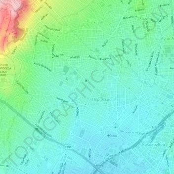
Naam: Topografische kaart Municipality of Peristeri, hoogte, reliëf.
Gemiddelde hoogte: 80 m
Minimale hoogte: 36 m
Maximale hoogte: 231 m
Andere topografische kaarten
Klik op een kaart om zijn topografie, zijn hoogte en zijn reliëf te bekijken.
Municipal Unit of Kamatero
Greece > Attica > Regional Unit of West Athens
Municipal Unit of Kamatero, Municipality of Agioi Anargyroi-Kamatero, Regional Unit of West Athens, Attica, 134 51, Greece
Gemiddelde hoogte: 153 m
Peristeri
Greece > Attica > Regional Unit of West Athens
Peristeri, Municipality of Peristeri, Regional Unit of West Athens, Attica, 121 34, Greece
Gemiddelde hoogte: 223 m
Municipality of Aigaleo
Greece > Attica > Regional Unit of West Athens
Municipality of Aigaleo, Regional Unit of West Athens, Attica, Greece
Gemiddelde hoogte: 46 m
Municipality of Petroupoli
Greece > Attica > Regional Unit of West Athens
Municipality of Petroupoli, Regional Unit of West Athens, Attica, 132 31, Greece
Gemiddelde hoogte: 222 m