
Topografische kaart Eskisehir
Interactieve kaart
Klik op de kaart om de hoogte weer te geven.
Over deze kaart
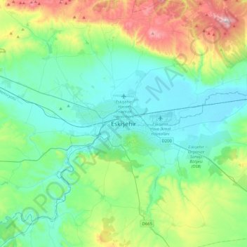
Naam: Topografische kaart Eskisehir, hoogte, reliëf.
Gemiddelde hoogte: 949 m
Minimale hoogte: 775 m
Maximale hoogte: 1.517 m
Eskişehir has a cold semi-arid climate (BSk) under the Köppen climate classification, and a temperate continental climate (Dc) under the Trewartha climate classification. The city features cold, snowy winters and warm, dry summers. Rainfall occurs mostly during the spring and autumn. Due to Eskişehir's high altitude and its dry summers, nightly temperatures in the summer months are cool. Precipitation levels are low, but precipitation can be observed throughout the year.