
Topografische kaart Kanyakumari
Interactieve kaart
Klik op de kaart om de hoogte weer te geven.
Over deze kaart
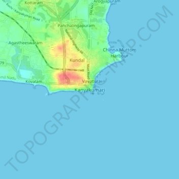
Naam: Topografische kaart Kanyakumari, hoogte, reliëf.
Gemiddelde hoogte: 6 m
Minimale hoogte: 0 m
Maximale hoogte: 55 m
Kanniyakumari is located at 8°05′N 77°34′E / 8.08°N 77.57°E / 8.08; 77.57. and has an average elevation of 30 metres. The peninsular tip of Kanniyakumari is bordered on three sides by the Laccadive Sea. It is located at the confluence of the Western Coastal Plains and Eastern Coastal Plains.
Andere topografische kaarten
Klik op een kaart om zijn topografie, zijn hoogte en zijn reliëf te bekijken.
Manakudy
India > Tamil Nadu > Agastheeswaram
Manakudy, Agastheeswaram, Kanniyakumari District, Tamil Nadu, 629602, India
Gemiddelde hoogte: 6 m
Karavilai
India > Tamil Nadu > Agastheeswaram
Karavilai, Agastheeswaram, Kanniyakumari District, Tamil Nadu, 629503, India
Gemiddelde hoogte: 28 m
Nagercoil
India > Tamil Nadu > Agastheeswaram
Nagercoil, Agastheeswaram, Kanniyakumari District, Tamil Nadu, 629001, India
Gemiddelde hoogte: 83 m