
Topografische kaart Groot-Brakrivier
Interactieve kaart
Klik op de kaart om de hoogte weer te geven.
Over deze kaart
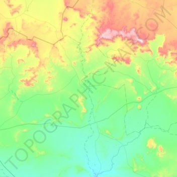
Naam: Topografische kaart Groot-Brakrivier, hoogte, reliëf.
Gemiddelde hoogte: 1.351 m
Minimale hoogte: 1.100 m
Maximale hoogte: 2.095 m
Andere topografische kaarten
Klik op een kaart om zijn topografie, zijn hoogte en zijn reliëf te bekijken.
Mountain Zebra National Park
RSA > Eastern Cape > Inxuba Yethemba Local Municipality
Mountain Zebra National Park, Umgeni Loop - 4x4 Route, Inxuba Yethemba Ward 6, Inxuba Yethemba Local Municipality, Chris Hani District Municipality, Eastern Cape, RSA
Gemiddelde hoogte: 1.230 m
Great Fish River
RSA > Eastern Cape > Inxuba Yethemba Local Municipality
Great Fish River, Inxuba Yethemba Local Municipality, Chris Hani District Municipality, Eastern Cape, RSA
Gemiddelde hoogte: 1.248 m
Grassridge Dam
RSA > Eastern Cape > Inxuba Yethemba Local Municipality
Grassridge Dam, Inxuba Yethemba Ward 6, Inxuba Yethemba Local Municipality, Chris Hani District Municipality, Eastern Cape, RSA
Gemiddelde hoogte: 1.059 m
Compassberg
RSA > Eastern Cape > Inxuba Yethemba Local Municipality
Compassberg, Inxuba Yethemba Local Municipality, Chris Hani District Municipality, Eastern Cape, RSA
Gemiddelde hoogte: 2.017 m