
Topografische kaart Livingston
Interactieve kaart
Klik op de kaart om de hoogte weer te geven.
Over deze kaart
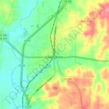
Naam: Topografische kaart Livingston, hoogte, reliëf.
Locatie: Livingston, Polk County, Texas, United States (30.68262 -94.97029 30.74201 -94.90823)
Gemiddelde hoogte: 63 m
Minimale hoogte: 28 m
Maximale hoogte: 116 m
Elevation: 148 ft
Andere topografische kaarten
Klik op een kaart om zijn topografie, zijn hoogte en zijn reliëf te bekijken.
Tobacco Patch
United States > Texas > Polk County
Tobacco Patch, Polk County, Texas, United States
Gemiddelde hoogte: 43 m
Israel
United States > Texas > Polk County
Israel, Polk County, Texas, United States
Gemiddelde hoogte: 87 m
Seven Oaks
United States > Texas > Polk County
Seven Oaks, Polk County, Texas, United States
Gemiddelde hoogte: 68 m
Goodrich
United States > Texas > Polk County
Goodrich, Polk County, Texas, United States
Gemiddelde hoogte: 38 m