
Topografische kaart Khorramabad
Interactieve kaart
Klik op de kaart om de hoogte weer te geven.
Over deze kaart
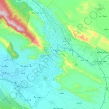
Naam: Topografische kaart Khorramabad, hoogte, reliëf.
Gemiddelde hoogte: 1.365 m
Minimale hoogte: 1.125 m
Maximale hoogte: 2.391 m
Khorramabad has what is classed under the Köppen climate classification as a Hot-summer Mediterranean climate (Csa) climate. Its elevation is 1147.8 above sea level. Average annual precipitation is 511.06 and its average annual temperature is 17.21 Celsius.