
Topografische kaart Rodolfo Aguilar Delgado
Interactieve kaart
Klik op de kaart om de hoogte weer te geven.
Over deze kaart
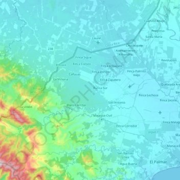
Naam: Topografische kaart Rodolfo Aguilar Delgado, hoogte, reliëf.
Locatie: Rodolfo Aguilar Delgado, Distrito Barú, Chiriquí, Panamá (8.33303 -83.04791 8.43837 -82.84158)
Gemiddelde hoogte: 86 m
Minimale hoogte: 0 m
Maximale hoogte: 707 m
Andere topografische kaarten
Klik op een kaart om zijn topografie, zijn hoogte en zijn reliëf te bekijken.
Buena Vista (Spanish Town)
Panamá > Chiriquí > Distrito Barú > Puerto Armuelles > Monte Verde
Buena Vista (Spanish Town), Monte Verde, Puerto Armuelles, Distrito Barú, Chiriquí, 0406, Panamá
Gemiddelde hoogte: 21 m
Puerto Armuelles
Panamá > Chiriquí > Distrito Barú
Puerto Armuelles, Distrito Barú, Chiriquí, Panamá
Gemiddelde hoogte: 46 m
Río Chiriquí Viejo
Panamá > Chiriquí > Distrito Barú > Progreso
Río Chiriquí Viejo, Progreso, Distrito Barú, Chiriquí, Panamá
Gemiddelde hoogte: 19 m
Charco Azul Bay
Panamá > Chiriquí > Distrito Barú > Rodolfo Aguilar Delgado
Charco Azul Bay, Rodolfo Aguilar Delgado, Distrito Barú, Chiriquí, Panamá
Gemiddelde hoogte: 29 m