
Topografische kaart Kernevest
Interactieve kaart
Klik op de kaart om de hoogte weer te geven.
Over deze kaart
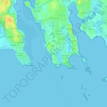
Naam: Topografische kaart Kernevest, hoogte, reliëf.
Gemiddelde hoogte: 3 m
Minimale hoogte: -1 m
Maximale hoogte: 28 m
Andere topografische kaarten
Klik op een kaart om zijn topografie, zijn hoogte en zijn reliëf te bekijken.
Kerroch
France > Bretagne > Morbihan > Saint-Philibert
Kerroch, Saint-Philibert, Lorient, Morbihan, Bretagne, France métropolitaine, 56470, France
Gemiddelde hoogte: 9 m
Kermouroux
France > Bretagne > Morbihan > Saint-Philibert
Kermouroux, Saint-Philibert, Lorient, Morbihan, Bretagne, France métropolitaine, 56470, France
Gemiddelde hoogte: 7 m
Larmor
France > Bretagne > Morbihan > Saint-Philibert
Larmor, Saint-Philibert, Lorient, Morbihan, Bretagne, France métropolitaine, 56470, France
Gemiddelde hoogte: 5 m
Pen er Stêr
France > Bretagne > Morbihan > Saint-Philibert > Pen er Stêr
Pen er Stêr, Saint-Philibert, Lorient, Morbihan, Bretagne, France métropolitaine, 56470, France
Gemiddelde hoogte: 8 m
Kerran
France > Bretagne > Morbihan > Saint-Philibert
Kerran, Saint-Philibert, Lorient, Morbihan, Bretagne, France métropolitaine, 56470, France
Gemiddelde hoogte: 9 m
Les Presses
France > Bretagne > Morbihan > Saint-Philibert
Les Presses, Saint-Philibert, Lorient, Morbihan, Bretagne, France métropolitaine, 56470, France
Gemiddelde hoogte: 7 m
Kerzuc
France > Bretagne > Morbihan > Saint-Philibert
Kerzuc, Saint-Philibert, Lorient, Morbihan, Bretagne, France métropolitaine, 56470, France
Gemiddelde hoogte: 8 m
Kerarno
France > Bretagne > Morbihan > Saint-Philibert
Kerarno, Saint-Philibert, Lorient, Morbihan, Bretagne, France métropolitaine, 56470, France
Gemiddelde hoogte: 5 m