
Topografische kaart Rogersville
Interactieve kaart
Klik op de kaart om de hoogte weer te geven.
Over deze kaart
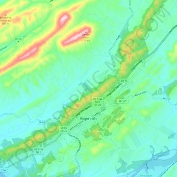
Naam: Topografische kaart Rogersville, hoogte, reliëf.
Gemiddelde hoogte: 416 m
Minimale hoogte: 324 m
Maximale hoogte: 716 m
Rogersville is located slightly southwest of the center of Hawkins County. According to the United States Census Bureau, the town has a total area of 3.4 square miles (8.8 km2), all land. The town is in the valley of Crockett Creek, a southwest-flowing tributary of the Holston River. The elevation of Rogersville is 1,286 feet (392 m). Via U.S. Route 11W (see below), it is 28 miles (45 km) southwest of Kingsport and 65 miles (105 km) northeast of Knoxville.