
Topografische kaart Bamberton Provincial Park
Interactieve kaart
Klik op de kaart om de hoogte weer te geven.
Over deze kaart
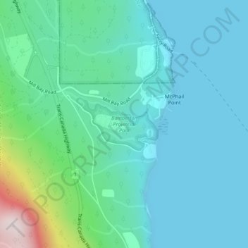
Naam: Topografische kaart Bamberton Provincial Park, hoogte, reliëf.
Gemiddelde hoogte: 97 m
Minimale hoogte: 0 m
Maximale hoogte: 554 m
Andere topografische kaarten
Klik op een kaart om zijn topografie, zijn hoogte en zijn reliëf te bekijken.
Mill Bay
Canada > British Columbia > Cowichan Valley Regional District > Area A (Mill Bay / Malahat)
Mill Bay, Area A (Mill Bay / Malahat), Cowichan Valley Regional District, British Columbia, V0R 2P1, Canada
Gemiddelde hoogte: 61 m
H500
Canada > British Columbia > Cowichan Valley Regional District > Area A (Mill Bay / Malahat)
H500, Area A (Mill Bay / Malahat), Cowichan Valley Regional District, British Columbia, V0R 2P4, Canada
Gemiddelde hoogte: 341 m