
Topografische kaart Chez Chevroux
Interactieve kaart
Klik op de kaart om de hoogte weer te geven.
Over deze kaart
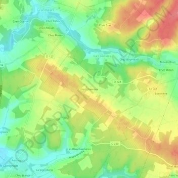
Naam: Topografische kaart Chez Chevroux, hoogte, reliëf.
Gemiddelde hoogte: 43 m
Minimale hoogte: 7 m
Maximale hoogte: 83 m
Andere topografische kaarten
Klik op een kaart om zijn topografie, zijn hoogte en zijn reliëf te bekijken.
Saint-Hilaire-de-Villefranche
France > Nouvelle-Aquitaine > Charente-Maritime > Saint-Hilaire-de-Villefranche
Saint-Hilaire-de-Villefranche, Saint-Jean-d'Angély, Charente-Maritime, Nouvelle-Aquitaine, France métropolitaine, 17770, France
Gemiddelde hoogte: 55 m
Chez Dyon
France > Nouvelle-Aquitaine > Charente-Maritime > Saint-Hilaire-de-Villefranche
Chez Dyon, Saint-Hilaire-de-Villefranche, Saint-Jean-d'Angély, Charente-Maritime, Nouvelle-Aquitaine, France métropolitaine, 17770, France
Gemiddelde hoogte: 55 m
Les Ormeaux
France > Nouvelle-Aquitaine > Charente-Maritime > Saint-Hilaire-de-Villefranche
Les Ormeaux, Saint-Hilaire-de-Villefranche, Saint-Jean-d'Angély, Charente-Maritime, Nouvelle-Aquitaine, France métropolitaine, 17770, France
Gemiddelde hoogte: 55 m