
Topografische kaart Durg
Interactieve kaart
Klik op de kaart om de hoogte weer te geven.
Over deze kaart
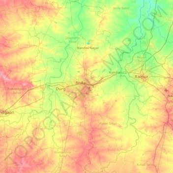
Naam: Topografische kaart Durg, hoogte, reliëf.
Locatie: Durg, Chhattisgarh, India (20.85031 81.14466 21.54485 81.62513)
Gemiddelde hoogte: 295 m
Minimale hoogte: 255 m
Maximale hoogte: 347 m
Andere topografische kaarten
Klik op een kaart om zijn topografie, zijn hoogte en zijn reliëf te bekijken.
Durg
India > Chhattisgarh > Durg
Durg, Durg Tahsil, Durg, Chhattisgarh, 491002, India
Gemiddelde hoogte: 295 m
Raipur
India > Chhattisgarh > Raipur
Raipur, Raipur Tahsil, Raipur, Chhattisgarh, 493332, India
Gemiddelde hoogte: 288 m