
Topografische kaart Ojén
Interactieve kaart
Klik op de kaart om de hoogte weer te geven.
Over deze kaart
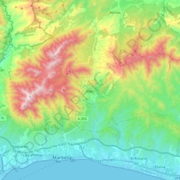
Naam: Topografische kaart Ojén, hoogte, reliëf.
Locatie: Ojén, Sierra de las Nieves, Malaga, Andalusia, 29610, Spain (36.52108 -4.92218 36.60949 -4.73540)
Gemiddelde hoogte: 404 m
Minimale hoogte: -1 m
Maximale hoogte: 1.254 m
The town is situated beside the Almadán stream above the valley of the River Real at an altitude of approximately 200 metres, hemmed in by the Sierra Blanca and the Sierra Alpujata. These may provide a clue to the Moors' determination to stay in spite of their apparent antipathy, for both ranges of mountains have long been known as rich sources of talc, nickel, iron and lead. This mineral wealth put the area in the forefront of the Spanish industrial revolution of the 19th century.
Andere topografische kaarten
Klik op een kaart om zijn topografie, zijn hoogte en zijn reliëf te bekijken.
Casarabonela
Spain > Andalusia > Sierra de las Nieves
Casarabonela, Sierra de las Nieves, Malaga, Andalusia, Spain
Gemiddelde hoogte: 559 m