
Topografische kaart Allegany County
Interactieve kaart
Klik op de kaart om de hoogte weer te geven.
Over deze kaart
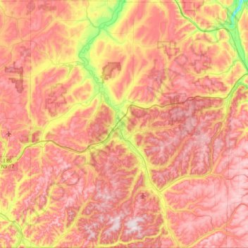
Naam: Topografische kaart Allegany County, hoogte, reliëf.
Locatie: Allegany County, New York, United States of America (41.99822 -78.30816 42.52002 -77.72294)
Gemiddelde hoogte: 561 m
Minimale hoogte: 268 m
Maximale hoogte: 779 m
Allegany County is in the southwestern part of New York State, along the Pennsylvania border. Allegany County does not lie along the Allegheny River, as its name would suggest. The highest point in the county is Alma Hill, with an elevation of 2,548 feet above sea level. This is the highest point in the state west of the Catskill Mountains. The highest point of Interstate 86 is located in the Town of West Almond with an elevation of 2,110 feet. This is also believed to be the highest point of any interstate in the New York. The County is unique from a watershed perspective as it is providing water to three major watersheds of North America: The eastern part near Alfred has Canacadea Creek that goes into the Canisteo River, Susquehanna River and eventually to Chesapeake Bay.
Andere topografische kaarten
Klik op een kaart om zijn topografie, zijn hoogte en zijn reliëf te bekijken.
Parish
United States of America > New York > Parish
Parish, Town of Parish, Oswego County, New York, 13131, United States of America
Gemiddelde hoogte: 147 m
Yonkers
United States of America > New York > Yonkers
Yonkers, Westchester County, New York, United States of America
Gemiddelde hoogte: 58 m
Saratoga County
United States of America > New York
Saratoga County, New York, United States of America
Gemiddelde hoogte: 218 m
Gordon Heights
United States of America > New York
Gordon Heights, Suffolk, New York, United States of America
Gemiddelde hoogte: 40 m
Farmingville
United States of America > New York > Farmingville
Farmingville, Suffolk, New York, 11738, United States of America
Gemiddelde hoogte: 47 m
Smithtown
United States of America > New York
Smithtown, Suffolk, New York, 11787, United States of America
Gemiddelde hoogte: 29 m
Middle Island
United States of America > New York
Middle Island, Suffolk, New York, 11953, United States of America
Gemiddelde hoogte: 31 m
New York County
United States of America > New York > Manhattan Community Board 9
New York County, Manhattan Community Board 9, New York, United States of America
Gemiddelde hoogte: 18 m
Lock C5
United States of America > New York
Lock C5, Town of Saratoga, Saratoga County, New York, 12834:12871, United States of America
Gemiddelde hoogte: 52 m
WCBS-AM (New York)
United States of America > New York > New York
WCBS-AM (New York), Terrace Street, City Island, New York, The Bronx, Bronx County, New York, 10464, United States of America
Gemiddelde hoogte: 1 m
Queens
United States of America > New York > New York
Queens, Queens County, New York, United States of America
Gemiddelde hoogte: 12 m
Newburgh
United States of America > New York > Newburgh
Newburgh, Orange County, New York, United States of America
Gemiddelde hoogte: 32 m
Phoenix
United States of America > New York > Phoenix
Phoenix, Town of Schroeppel, Oswego County, New York, United States of America
Gemiddelde hoogte: 117 m
Syracuse
United States of America > New York > Syracuse
Syracuse, Onondaga County, New York, United States of America
Gemiddelde hoogte: 172 m
Brooklyn
United States of America > New York > New York
Brooklyn, Kings County, New York, United States of America
Gemiddelde hoogte: 10 m
ny
United States of America > New York > ny
ny, Suffolk County, New York, United States of America
Gemiddelde hoogte: 18 m
Bronx County
United States of America > New York > New York
Bronx County, New York, United States of America
Gemiddelde hoogte: 21 m
Hauppauge
United States of America > New York > Hauppauge
Hauppauge, Suffolk, New York, 11788, United States of America
Gemiddelde hoogte: 30 m
Saint Lawrence
United States of America > New York
Saint Lawrence, New York, United States of America
Gemiddelde hoogte: 239 m