
Topografische kaart Town of Bridgewater
Interactieve kaart
Klik op de kaart om de hoogte weer te geven.
Over deze kaart
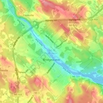
Naam: Topografische kaart Town of Bridgewater, hoogte, reliëf.
Locatie: Town of Bridgewater, Lunenburg County, Nova Scotia, Canada (44.35760 -64.56427 44.40550 -64.48875)
Gemiddelde hoogte: 56 m
Minimale hoogte: -2 m
Maximale hoogte: 118 m
Bridgewater spans the width of the LaHave River Valley and is dominated by hills that lead down to the river. Elevations range from 5 metres above sea level at the river, to nearly 110 m at the southwestern border. Like much of Southern Nova Scotia, the surrounding area is characterized by rolling drumlins formed during the last glacial period, some of which reach 150 metres above sea level. The LaHave River is traversed by two bridges in the centre of the town, as well as a 103 highway overpass and foot bridge towards the northern limits.
Andere topografische kaarten
Klik op een kaart om zijn topografie, zijn hoogte en zijn reliëf te bekijken.
New Russell
Canada > Nova Scotia > Lunenburg County
New Russell, Chester District Municipality, Lunenburg County, Nova Scotia, B0J 2M0, Canada
Gemiddelde hoogte: 205 m
Forties
Canada > Nova Scotia > Lunenburg County
Forties, Chester District Municipality, Lunenburg County, Nova Scotia, B0J 2M0, Canada
Gemiddelde hoogte: 157 m
New Ross
Canada > Nova Scotia > Lunenburg County
New Ross, Chester District Municipality, Lunenburg County, Nova Scotia, B0J 2M0, Canada
Gemiddelde hoogte: 155 m
Upper Kingsburg
Canada > Nova Scotia > Lunenburg County
Upper Kingsburg, Municipality of the District of Lunenburg, Lunenburg County, Nova Scotia, B0J 2X0, Canada
Gemiddelde hoogte: 9 m
Mahone Bay
Canada > Nova Scotia > Lunenburg County > Big Tancook Island
Mahone Bay, Big Tancook Island, Municipality of the District of Lunenburg, Lunenburg County, Nova Scotia, B0J 1J0, Canada
Gemiddelde hoogte: 10 m
Lower LaHave
Canada > Nova Scotia > Lunenburg County
Lower LaHave, Municipality of the District of Lunenburg, Lunenburg County, Nova Scotia, B0J 2W0, Canada
Gemiddelde hoogte: 13 m
Bridgewater
Canada > Nova Scotia > Lunenburg County
Bridgewater, Lunenburg County, Nova Scotia, Canada
Gemiddelde hoogte: 56 m
Hubbards
Canada > Nova Scotia > Lunenburg County > Hubbards
Hubbards, Chester District Municipality, Lunenburg County, Nova Scotia, B0J 1T0, Canada
Gemiddelde hoogte: 57 m
Riverport
Canada > Nova Scotia > Lunenburg County
Riverport, Municipality of the District of Lunenburg, Lunenburg County, Nova Scotia, Canada
Gemiddelde hoogte: 23 m
Hebbs Cross
Canada > Nova Scotia > Lunenburg County
Hebbs Cross, Municipality of the District of Lunenburg, Lunenburg County, Nova Scotia, Canada
Gemiddelde hoogte: 74 m
Oak Island
Canada > Nova Scotia > Lunenburg County > Western Shore
Oak Island, Western Shore, Chester District Municipality, Lunenburg County, Nova Scotia, B0J 3M0, Canada
Gemiddelde hoogte: 74 m
Harriston
Canada > Nova Scotia > Lunenburg County
Harriston, Chester District Municipality, Lunenburg County, Nova Scotia, Canada
Gemiddelde hoogte: 183 m