
Topografische kaart Kefalonia
Interactieve kaart
Klik op de kaart om de hoogte weer te geven.
Over deze kaart
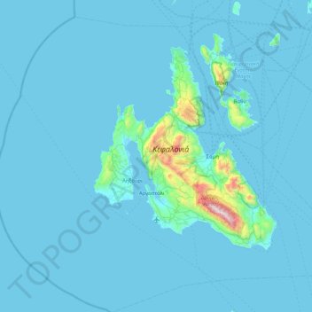
Naam: Topografische kaart Kefalonia, hoogte, reliëf.
Gemiddelde hoogte: 60 m
Minimale hoogte: -1 m
Maximale hoogte: 1.601 m
Andere topografische kaarten
Klik op een kaart om zijn topografie, zijn hoogte en zijn reliëf te bekijken.
Pastra
Greece > Peloponnese, Western Greece and the Ionian > Kefallonia Regional Unit > Municipal Unit of Elios-Proni
Pastra, Municipal Unit of Elios-Proni, Argostoli Municipality, Kefallonia Regional Unit, Ioanian Islands, Peloponnese, Western Greece and the Ionian, 280 82, Greece
Gemiddelde hoogte: 305 m
Argostoli
Greece > Peloponnese, Western Greece and the Ionian > Kefallonia Regional Unit
Argostoli, Argostoli Municipality, Kefallonia Regional Unit, Ioanian Islands, Peloponnese, Western Greece and the Ionian, 281 00, Greece
Gemiddelde hoogte: 79 m
Katelios
Greece > Peloponnese, Western Greece and the Ionian > Kefallonia Regional Unit > Municipal Unit of Elios-Proni > Kato Katelios > Katelios
Katelios, Kato Katelios, Municipal Unit of Elios-Proni, Argostoli Municipality, Kefallonia Regional Unit, Ioanian Islands, Peloponnese, Western Greece and the Ionian, 28082, Greece
Gemiddelde hoogte: 180 m
Cephalonia
Greece > Peloponnese, Western Greece and the Ionian > Kefallonia Regional Unit
Cephalonia, Kefallonia Regional Unit, Ioanian Islands, Peloponnese, Western Greece and the Ionian, Greece
Gemiddelde hoogte: 138 m
Sami
Greece > Peloponnese, Western Greece and the Ionian > Kefallonia Regional Unit > Sami Municipal Unit
Sami, Sami Municipal Unit, Sami Municipality, Kefallonia Regional Unit, Ioanian Islands, Peloponnese, Western Greece and the Ionian, 280 80, Greece
Gemiddelde hoogte: 200 m