
Topografische kaart Cirque of the Towers
Interactieve kaart
Klik op de kaart om de hoogte weer te geven.
Over deze kaart
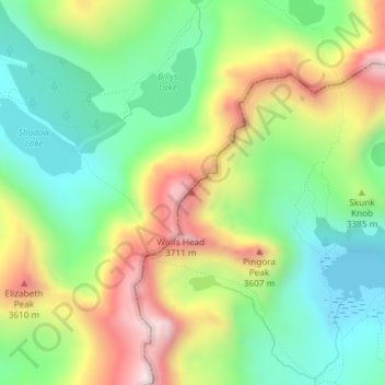
Naam: Topografische kaart Cirque of the Towers, hoogte, reliëf.
Gemiddelde hoogte: 3.347 m
Minimale hoogte: 3.095 m
Maximale hoogte: 3.737 m
Andere topografische kaarten
Klik op een kaart om zijn topografie, zijn hoogte en zijn reliëf te bekijken.
Sweetwater Station
United States > Wyoming > Fremont County
Sweetwater Station, Fremont County, Wyoming, United States
Gemiddelde hoogte: 2.021 m
Dubois
United States > Wyoming > Fremont County
Dubois, Fremont County, Wyoming, 82513, United States
Gemiddelde hoogte: 2.167 m
Arapahoe
United States > Wyoming > Fremont County
Arapahoe, Fremont County, Wyoming, United States
Gemiddelde hoogte: 1.555 m
Fort Washakie
United States > Wyoming > Fremont County
Fort Washakie, Fremont County, Wyoming, 82514, United States
Gemiddelde hoogte: 1.742 m
Pavillion
United States > Wyoming > Fremont County
Pavillion, Fremont County, Wyoming, 82523, United States
Gemiddelde hoogte: 1.665 m
Whiskey Mountain
United States > Wyoming > Fremont County
Whiskey Mountain, Fremont County, Wyoming, United States
Gemiddelde hoogte: 3.177 m
Mount Popo Agie
United States > Wyoming > Fremont County
Mount Popo Agie, Fremont County, Wyoming, United States
Gemiddelde hoogte: 2.848 m
Boysen State Park
United States > Wyoming > Fremont County > Shoshoni
Boysen State Park, Shoshoni, Fremont County, Wyoming, United States
Gemiddelde hoogte: 1.553 m
Dinwoody Lake
United States > Wyoming > Fremont County
Dinwoody Lake, Fremont County, Wyoming, United States
Gemiddelde hoogte: 2.074 m
Riverton
United States > Wyoming > Fremont County
Riverton, Fremont County, Wyoming, 82501, United States
Gemiddelde hoogte: 1.529 m
Fremont Peak
United States > Wyoming > Fremont County
Fremont Peak, Fremont County, Wyoming, United States
Gemiddelde hoogte: 3.703 m