
Topografische kaart Tagaytay
Interactieve kaart
Klik op de kaart om de hoogte weer te geven.
Over deze kaart
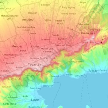
Naam: Topografische kaart Tagaytay, hoogte, reliëf.
Locatie: Tagaytay, Cavite, Calabarzon, 4120, Philippines (14.07911 120.88591 14.15765 121.05140)
Gemiddelde hoogte: 314 m
Minimale hoogte: 3 m
Maximale hoogte: 728 m
The southern and eastern portions of Tagaytay are covered by hills and mountains which is generally forests, pine trees and open grasslands. The city lies along Tagaytay Ridge, a ridge stretching about 32 kilometres (20 mi) from Mount Batulao in the west to Mount Sungay in the east with elevations averaging about 610 metres (2,000 ft) above sea level. Mount Sungay, in Tagaytay, is the highest point of the province of Cavite at 709 metres (2,326 ft).
Andere topografische kaarten
Klik op een kaart om zijn topografie, zijn hoogte en zijn reliëf te bekijken.
Asisan
Philippines > Cavite > Tagaytay
Asisan, Tagaytay, Cavite, Calabarzon, 4120, Philippines
Gemiddelde hoogte: 526 m
Tagaytay
Philippines > Cavite > Tagaytay
Tagaytay, Cavite, Calabarzon, 4120, Philippines
Gemiddelde hoogte: 225 m