
Topografische kaart Blonay
Interactieve kaart
Klik op de kaart om de hoogte weer te geven.
Over deze kaart
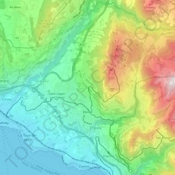
Naam: Topografische kaart Blonay, hoogte, reliëf.
Gemiddelde hoogte: 885 m
Minimale hoogte: 367 m
Maximale hoogte: 1.733 m
Blonay overlooks Lake Geneva, with the hill 'Les Pléiades' behind the town. The municipality stretches from an elevation of about 500 to 1,400 m (1,600 to 4,600 ft). It consists of the village of Blonay with the sections of Tercier and Cojonnex and a number of hamlets including Les Chevalleyres.
Andere topografische kaarten
Klik op een kaart om zijn topografie, zijn hoogte en zijn reliëf te bekijken.
Veveyse
Switzerland > Vaud > District de la Riviera-Pays-d’Enhaut > Blonay - Saint-Légier
Veveyse, Blonay - Saint-Légier, District de la Riviera-Pays-d’Enhaut, Vaud, 1809, Switzerland
Gemiddelde hoogte: 742 m