
Topografische kaart Moscow
Interactieve kaart
Klik op de kaart om de hoogte weer te geven.
Over deze kaart
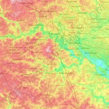
Naam: Topografische kaart Moscow, hoogte, reliëf.
Locatie: Moscow, Central Federal District, Russia (55.14217 36.80310 56.02122 37.96743)
Gemiddelde hoogte: 177 m
Minimale hoogte: 108 m
Maximale hoogte: 255 m
Moscow is situated on the banks of the Moskva River, which flows for just over 500 km (311 mi) through the East European Plain in central Russia. 49 bridges span the river and its canals within the city's limits. The elevation of Moscow at the All-Russia Exhibition Center (VVC), where the leading Moscow weather station is situated, is 156 metres (512 feet). Teplostanskaya highland is the city's highest point at 255 metres (837 feet). The width of Moscow city (not limiting MKAD) from west to east is 39.7 km (24.7 mi), and the length from north to south is 51.8 km (32.2 mi).
Andere topografische kaarten
Klik op een kaart om zijn topografie, zijn hoogte en zijn reliëf te bekijken.
Prospekt Vernadskogo District
Russia > Moscow > Prospekt Vernadskogo District
Prospekt Vernadskogo District, Western Administrative Okrug, Moscow, Central Federal District, Russia
Gemiddelde hoogte: 185 m