
Topografische kaart Baldwin
Interactieve kaart
Klik op de kaart om de hoogte weer te geven.
Over deze kaart
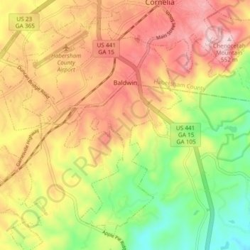
Naam: Topografische kaart Baldwin, hoogte, reliëf.
Locatie: Baldwin, Habersham County, Georgia, United States (34.45432 -83.59457 34.50830 -83.52045)
Gemiddelde hoogte: 395 m
Minimale hoogte: 235 m
Maximale hoogte: 544 m
Andere topografische kaarten
Klik op een kaart om zijn topografie, zijn hoogte en zijn reliëf te bekijken.
Tugaloo
United States > Georgia > Habersham County > Tallulah Falls
Tugaloo, Tallulah Falls, Habersham County, Georgia, United States
Gemiddelde hoogte: 392 m
Turnerville
United States > Georgia > Habersham County
Turnerville, Habersham County, Georgia, 30580, United States
Gemiddelde hoogte: 463 m
Habersham
United States > Georgia > Habersham County
Habersham, Habersham County, Georgia, 30544, United States
Gemiddelde hoogte: 409 m
Clarkesville
United States > Georgia > Habersham County
Clarkesville, Habersham County, Georgia, United States
Gemiddelde hoogte: 418 m
Mount Airy
United States > Georgia > Habersham County
Mount Airy, Habersham County, Georgia, United States
Gemiddelde hoogte: 443 m
Demorest
United States > Georgia > Habersham County
Demorest, Habersham County, Georgia, United States
Gemiddelde hoogte: 416 m
Apple Pie Mountain
United States > Georgia > Habersham County
Apple Pie Mountain, Habersham County, Georgia, 30573, United States
Gemiddelde hoogte: 537 m
Cornelia
United States > Georgia > Habersham County
Cornelia, Habersham County, Georgia, United States
Gemiddelde hoogte: 446 m
Tallulah Falls
United States > Georgia > Habersham County
Tallulah Falls, Habersham County, Georgia, United States
Gemiddelde hoogte: 488 m