
Topografische kaart Cranleigh
Interactieve kaart
Klik op de kaart om de hoogte weer te geven.
Cranleigh
Elevations range from a maximum of 240 m AOD (mean high water level) at the car park on Reynolds Hill in Winterfold Heath (a woodland in the north) to 41 m on the watercourse and the disused Wey and Arun Canal as they leave both the parish in the northwest extreme at the end of East Whipley Lane. The village centre lies at generally 50–70 m above AOD.
Over deze kaart
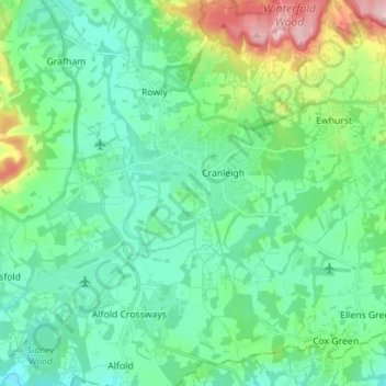
Naam: Topografische kaart Cranleigh, hoogte, reliëf.
Gemiddelde hoogte: 78 m
Minimale hoogte: 24 m
Maximale hoogte: 257 m