
Topografische kaart Sincelejo
Interactieve kaart
Klik op de kaart om de hoogte weer te geven.
Over deze kaart
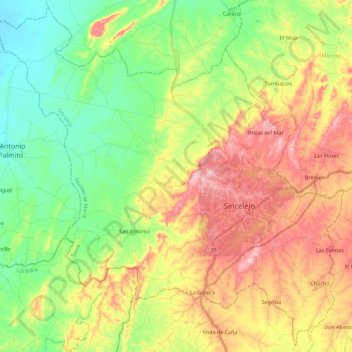
Naam: Topografische kaart Sincelejo, hoogte, reliëf.
Locatie: Sincelejo, Montes de María, Sucre, RAP Caribe, Colombia (9.20842 -75.55096 9.42236 -75.32598)
Gemiddelde hoogte: 115 m
Minimale hoogte: 17 m
Maximale hoogte: 250 m
Andere topografische kaarten
Klik op een kaart om zijn topografie, zijn hoogte en zijn reliëf te bekijken.
Sincelejo
The geography of Sincelejo is characterized by a hilly landscape which extends from the mountains to the borders of the plateau in the north and south. The small mountain foothills in the municipality span from the marine fluvial plain in the west to the border shared with the town of Palmito. Erosion is…
Gemiddelde hoogte: 121 m