
Topografische kaart Rainham
Klik op de kaart om de hoogte weer te geven.
Over deze kaart
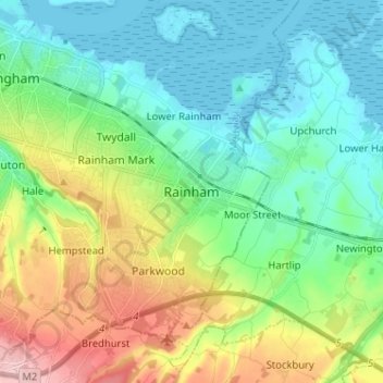
Naam: Topografische kaart Rainham, hoogte, reliëf.
Locatie: Rainham, Gillingham, Kent, England, ME8 7JH, United Kingdom (51.32331 0.56836 51.40331 0.64836)
Gemiddelde hoogte: 52 m
Minimale hoogte: -2 m
Maximale hoogte: 176 m
Andere topografische kaarten
Klik op een kaart om zijn topografie, zijn hoogte en zijn reliëf te bekijken.
Romney, Hythe and Dymchurch Railway
United Kingdom > England > Kent > Folkestone and Hythe > St. Mary in the Marsh
Gemiddelde hoogte: 1 m
Ramsgate
United Kingdom > England > Kent > Thanet > Pegwell
In 2017 Ramsgate was chosen as one of the first ten Heritage Action Zones (HAZ) by Historic England, with the aim of stimulating economic growth by taking advantage of Ramsgate's historic environment. Part of this project included a Historic Landscape Characterisation Study which assessed and mapped the…
Gemiddelde hoogte: 25 m
Kings Hill
United Kingdom > England > Kent > Tonbridge and Malling > Kings Hill
Gemiddelde hoogte: 82 m