
Topografische kaart Ricketts Glen State Park
Interactieve kaart
Klik op de kaart om de hoogte weer te geven.
Over deze kaart
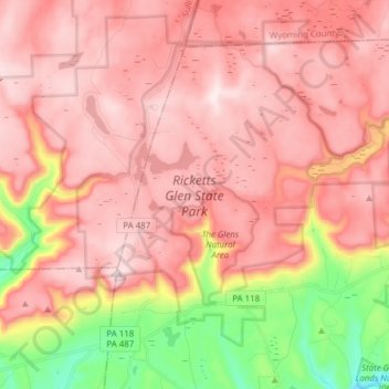
Naam: Topografische kaart Ricketts Glen State Park, hoogte, reliëf.
Gemiddelde hoogte: 588 m
Minimale hoogte: 282 m
Maximale hoogte: 751 m
The state's original plans for the new park included building an inn, an 18-hole golf course and country club, and a winter sports complex for skiing, ice boating, and tobogganing, as well as a beach with bathing facilities, cabins, and a tent camping area. Only the last three were actually built, all south of Lake Jean; the Hayfield area north of Lake Jean was to have had the facilities for golf and tennis, and the inn and winter sports complex were to have been atop Cherry Ridge, at an elevation of 2,461 feet (750 m).
Andere topografische kaarten
Klik op een kaart om zijn topografie, zijn hoogte en zijn reliëf te bekijken.
Lake Leigh Dam (defunct)
United States > Pennsylvania > Luzerne County > Fairmount Township
Lake Leigh Dam (defunct), Fairmount Township, Luzerne County, Pennsylvania, United States
Gemiddelde hoogte: 672 m
Red Rock
United States > Pennsylvania > Luzerne County > Fairmount Township
Red Rock, Fairmount Township, Luzerne County, Pennsylvania, United States
Gemiddelde hoogte: 438 m