Geolokaliseren

Topografische kaart Dundas

Klik op de kaart om de hoogte weer te geven.

Dundas

Dundas /ˈdʌnˌdæs/ is a community and former town in Hamilton, Ontario, Canada. It is nicknamed the Valley Town because of its topographical location at the bottom of the Niagara Escarpment on the western edge of Lake Ontario. The population has been stable for decades at about twenty thousand, largely because it has not annexed rural land from the protected Dundas Valley Conservation Area.

Over deze kaart

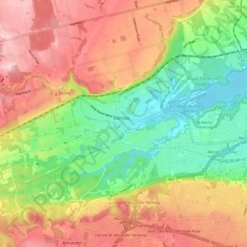
Naam: Topografische kaart Dundas, hoogte, reliëf.

Locatie: Dundas, Hamilton, Golden Horseshoe, Ontario, L9H 1T5, Canada (43.22619 -79.99463 43.30619 -79.91463)

Gemiddelde hoogte: 171 m

Minimale hoogte: 72 m

Maximale hoogte: 273 m

👉 Easily get elevation data in JSON, GeoTIFF and KML formats using Elevation API
Bedankt voor het steunen van deze site ❤️
Doe een donatie

Rust jezelf uit voor je volgende avontuur:

Als Amazon-partner verdient deze site een commissie op in aanmerking komende aankopen, zonder extra kosten voor jou.

Rust jezelf uit voor je volgende avontuur:

📱Outdoor Smartphonehouders - Bescherm je smartphone tijdens hikes
💧Herbruikbare Waterflessen - Hydratatie voor onderweg, milieuvriendelijk en licht
🪵Aanmaakblokjes - Start veilig een vuur op toegestane plekken
🕶️Outdoor Zonnebrillen - UV-bescherming voor berg en zee
🦟Insectenspray - Bescherm jezelf tegen teken en muggen in het bos

Als Amazon-partner verdient deze site een commissie op in aanmerking komende aankopen, zonder extra kosten voor jou.