
Doe een donatie
Rust jezelf uit voor je volgende avontuur:
Als Amazon-partner verdient deze site een commissie op in aanmerking komende aankopen, zonder extra kosten voor jou.
Topografische kaart Fillmore
Klik op de kaart om de hoogte weer te geven.
Doe een donatie
Rust jezelf uit voor je volgende avontuur:
Als Amazon-partner verdient deze site een commissie op in aanmerking komende aankopen, zonder extra kosten voor jou.
Fillmore
Fillmore is located at an elevation of 5,135 feet (1,565 m) in elevation. It lies in the Pahvant Valley, near the base of the Pahvant Mountain Range.
Doe een donatie
Rust jezelf uit voor je volgende avontuur:
Als Amazon-partner verdient deze site een commissie op in aanmerking komende aankopen, zonder extra kosten voor jou.
Over deze kaart
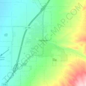
Naam: Topografische kaart Fillmore, hoogte, reliëf.
Locatie: Fillmore, Millard County, Utah, 84631, United States (38.93524 -112.37219 38.99876 -112.30076)
Gemiddelde hoogte: 1.584 m
Minimale hoogte: 1.493 m
Maximale hoogte: 1.809 m
Doe een donatie
Rust jezelf uit voor je volgende avontuur:
Als Amazon-partner verdient deze site een commissie op in aanmerking komende aankopen, zonder extra kosten voor jou.
Andere topografische kaarten
Klik op een kaart om zijn topografie, zijn hoogte en zijn reliëf te bekijken.