
Topografische kaart North Liberty
Interactieve kaart
Klik op de kaart om de hoogte weer te geven.
Over deze kaart
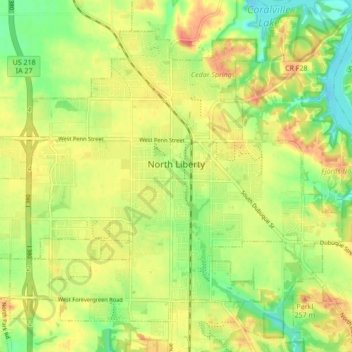
Naam: Topografische kaart North Liberty, hoogte, reliëf.
Locatie: North Liberty, Johnson County, Iowa, 52317, United States (41.71922 -91.65163 41.77198 -91.56608)
Gemiddelde hoogte: 235 m
Minimale hoogte: 206 m
Maximale hoogte: 262 m
North Liberty is located on the Iowan erosion surface. Drivers on I-380 experience an abrupt transition from the muted topography of the Iowan surface to the rolling hills of the Southern Iowa drift plain, four miles south of North Liberty.
Andere topografische kaarten
Klik op een kaart om zijn topografie, zijn hoogte en zijn reliëf te bekijken.
Tiffin
United States > Iowa > Johnson County
Tiffin, Johnson County, Iowa, 52340, United States
Gemiddelde hoogte: 227 m
Coralville
United States > Iowa > Johnson County
Coralville, Johnson County, Iowa, 52241, United States
Gemiddelde hoogte: 224 m
Iowa City
United States > Iowa > Johnson County > Iowa City
Iowa City, Johnson County, Iowa, 52240-5544, United States
Gemiddelde hoogte: 225 m
Hills
United States > Iowa > Johnson County
Hills, Johnson County, Iowa, 52235, United States
Gemiddelde hoogte: 196 m
Iowa City
United States > Iowa > Johnson County
Iowa City, Johnson County, Iowa, United States
Gemiddelde hoogte: 216 m