
Doe een donatie
Rust jezelf uit voor je volgende avontuur:
Als Amazon-partner verdient deze site een commissie op in aanmerking komende aankopen, zonder extra kosten voor jou.
Topografische kaart Eibar
Klik op de kaart om de hoogte weer te geven.
Doe een donatie
Rust jezelf uit voor je volgende avontuur:
Als Amazon-partner verdient deze site een commissie op in aanmerking komende aankopen, zonder extra kosten voor jou.
Eibar
Eibar lies at an altitude of 121m above sea level, in the west of the province of Gipuzkoa, right next to Biscay. Eibar has an oceanic climate. The town lies in a narrow valley in a mountainous area, the highest mountains are between 700 and 800 metres high. Eibar is traversed by river Ego, which is a tributary of the Deba.
Doe een donatie
Rust jezelf uit voor je volgende avontuur:
Als Amazon-partner verdient deze site een commissie op in aanmerking komende aankopen, zonder extra kosten voor jou.
Over deze kaart
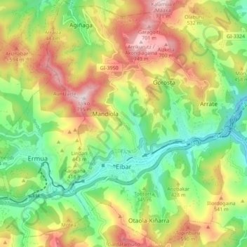
Naam: Topografische kaart Eibar, hoogte, reliëf.
Gemiddelde hoogte: 367 m
Minimale hoogte: 74 m
Maximale hoogte: 768 m
Doe een donatie
Rust jezelf uit voor je volgende avontuur:
Als Amazon-partner verdient deze site een commissie op in aanmerking komende aankopen, zonder extra kosten voor jou.
Andere topografische kaarten
Klik op een kaart om zijn topografie, zijn hoogte en zijn reliëf te bekijken.
Hondarribiko hondartza
Spain > Autonomous Community of the Basque Country > Gipuzkoako Bidasoa > Hondarribia
Gemiddelde hoogte: 31 m
Marabi
Spain > Autonomous Community of the Basque Country > Amorebieta-Etxano
Gemiddelde hoogte: 161 m
Doe een donatie
Rust jezelf uit voor je volgende avontuur:
Als Amazon-partner verdient deze site een commissie op in aanmerking komende aankopen, zonder extra kosten voor jou.
Gebara
Spain > Autonomous Community of the Basque Country > Arabako lautada/Llanada Alavesa
Gemiddelde hoogte: 574 m
Doe een donatie
Rust jezelf uit voor je volgende avontuur:
Als Amazon-partner verdient deze site een commissie op in aanmerking komende aankopen, zonder extra kosten voor jou.
Gorbeia
Spain > Autonomous Community of the Basque Country > Gorbeialdea > Zeanuri
Gemiddelde hoogte: 1.189 m
Karakate
Spain > Autonomous Community of the Basque Country > Debabarrena > Soraluze
Gemiddelde hoogte: 366 m
Doe een donatie
Rust jezelf uit voor je volgende avontuur:
Als Amazon-partner verdient deze site een commissie op in aanmerking komende aankopen, zonder extra kosten voor jou.
Santa Barbara
Spain > Autonomous Community of the Basque Country > Hernani > Sorgintxulo
Gemiddelde hoogte: 68 m
Bujal
Spain > Autonomous Community of the Basque Country > Añanako kuadrilla > Berantevilla
Gemiddelde hoogte: 535 m
Araneta
Spain > Autonomous Community of the Basque Country > Gasteizko kuadrilla/Cuadrilla de Vitoria > Vitoria-Gasteiz > Bolívar
Gemiddelde hoogte: 625 m
Soil
Spain > Autonomous Community of the Basque Country > Montaña Alavesa/Arabako Mendialdea
Gemiddelde hoogte: 898 m
Doe een donatie
Rust jezelf uit voor je volgende avontuur:
Als Amazon-partner verdient deze site een commissie op in aanmerking komende aankopen, zonder extra kosten voor jou.
Makola
Spain > Autonomous Community of the Basque Country > Urola-Kosta > Azkoitia
Gemiddelde hoogte: 515 m
Fuente Oneri
Spain > Autonomous Community of the Basque Country > Arabako lautada/Llanada Alavesa > Agurain/Salvatierra
Gemiddelde hoogte: 681 m
Iruka
Spain > Autonomous Community of the Basque Country > Debabarrena > Eibar
Gemiddelde hoogte: 425 m
Doe een donatie
Rust jezelf uit voor je volgende avontuur:
Als Amazon-partner verdient deze site een commissie op in aanmerking komende aankopen, zonder extra kosten voor jou.
Torrea
Spain > Autonomous Community of the Basque Country > Debabarrena > Eibar
Gemiddelde hoogte: 398 m
Flysch
Spain > Autonomous Community of the Basque Country > Urola-Kosta > Zumaia
Gemiddelde hoogte: 27 m
Barinatxe - La Salvaje
Spain > Autonomous Community of the Basque Country > Sopela
Gemiddelde hoogte: 26 m
Lore-Toki
Spain > Autonomous Community of the Basque Country > Arabako Errioxa/Rioja Alavesa > Labastida/Bastida
Gemiddelde hoogte: 499 m
Doe een donatie
Rust jezelf uit voor je volgende avontuur:
Als Amazon-partner verdient deze site een commissie op in aanmerking komende aankopen, zonder extra kosten voor jou.
Trevilla
Spain > Autonomous Community of the Basque Country > Karrantza Harana/Valle de Carranza > Concha
Gemiddelde hoogte: 333 m
Doe een donatie
Rust jezelf uit voor je volgende avontuur:
Als Amazon-partner verdient deze site een commissie op in aanmerking komende aankopen, zonder extra kosten voor jou.
Floreaga
Spain > Autonomous Community of the Basque Country > Urola-Kosta > Azkoitia
Gemiddelde hoogte: 266 m
Monterredondo
Spain > Autonomous Community of the Basque Country > Añanako kuadrilla/Cuadrilla de Añana
Gemiddelde hoogte: 875 m
Doe een donatie
Rust jezelf uit voor je volgende avontuur:
Als Amazon-partner verdient deze site een commissie op in aanmerking komende aankopen, zonder extra kosten voor jou.
Oñati
Spain > Autonomous Community of the Basque Country > Debagoiena > Oñati
Gemiddelde hoogte: 488 m
Plaza de Larrazábal
Spain > Autonomous Community of the Basque Country > Bilbao
Gemiddelde hoogte: 101 m
Doe een donatie
Rust jezelf uit voor je volgende avontuur:
Als Amazon-partner verdient deze site een commissie op in aanmerking komende aankopen, zonder extra kosten voor jou.
Gautegiz Arteaga
Spain > Autonomous Community of the Basque Country > Gautegiz Arteaga > Gautegiz Arteaga
Gemiddelde hoogte: 104 m
Zaldibar
Spain > Autonomous Community of the Basque Country > Zaldibar > Zaldibar
Gemiddelde hoogte: 305 m
Soil
Spain > Autonomous Community of the Basque Country > Montaña Alavesa/Arabako Mendialdea
Gemiddelde hoogte: 898 m