
Topografische kaart Bandar Abbas
Interactieve kaart
Klik op de kaart om de hoogte weer te geven.
Over deze kaart
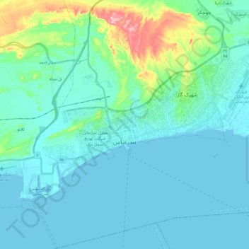
Naam: Topografische kaart Bandar Abbas, hoogte, reliëf.
Gemiddelde hoogte: 27 m
Minimale hoogte: -5 m
Maximale hoogte: 187 m
Bandar Abbas is situated on flat ground with an average altitude of 9 metres (30 ft) above sea level. The nearest elevated areas are Mt. Geno, 17 kilometres (11 mi) to the north, and Mt. Pooladi, 16 kilometres (9.9 mi) to the northwest of the city. The closest river to Bandar Abbas is the River Shoor, which rises on Mt. Geno and flows into the Persian Gulf, 10 kilometres (6.2 mi) east of the city. South of the city is the island of Qeshm.