
Topografische kaart The Bunker
Interactieve kaart
Klik op de kaart om de hoogte weer te geven.
Over deze kaart
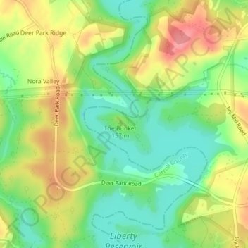
Naam: Topografische kaart The Bunker, hoogte, reliëf.
Locatie: The Bunker, Towson, Baltimore County, Maryland, USA (39.45533 -76.88753 39.45543 -76.88743)
Gemiddelde hoogte: 152 m
Minimale hoogte: 114 m
Maximale hoogte: 197 m
Andere topografische kaarten
Klik op een kaart om zijn topografie, zijn hoogte en zijn reliëf te bekijken.
Loch Raven Reservoir
Loch Raven Reservoir, Dulaney Valley Road, Towson, Baltimore County, Maryland, 21093, USA
Gemiddelde hoogte: 113 m
Hart-Miller Island
Hart-Miller Island, Towson, Baltimore County, Maryland, USA
Gemiddelde hoogte: 2 m
Mingo Branch
United States > Maryland > Towson
Mingo Branch, Baltimore County, Maryland, 21120, United States
Gemiddelde hoogte: 173 m
Cromwell Valley Park
Cromwell Valley Park, Satyr Hill Estates, Towson, Baltimore County, Maryland, USA
Gemiddelde hoogte: 106 m