
Topografische kaart Prunedale
Interactieve kaart
Klik op de kaart om de hoogte weer te geven.
Over deze kaart
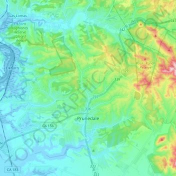
Naam: Topografische kaart Prunedale, hoogte, reliëf.
Locatie: Prunedale, Monterey County, California, United States (36.74904 -121.74431 36.86844 -121.57276)
Gemiddelde hoogte: 104 m
Minimale hoogte: -7 m
Maximale hoogte: 430 m
Prunedale is a unincorporated community in Monterey County, California, United States. It is located 8 miles (13 km) north of Salinas at an elevation of 92 feet (28 m). The population was 18,885 as of the 2020 census, up from 17,560 in 2010. For statistical purposes, the United States Census Bureau has defined Prunedale as a census-designated place (CDP). Plum trees were grown in Prunedale in the early days of its founding, but the trees died soon after due to poor irrigation and fertilizer.
Andere topografische kaarten
Klik op een kaart om zijn topografie, zijn hoogte en zijn reliëf te bekijken.
Prunedale
United States > California > Monterey County > Prunedale
Prunedale, Monterey County, California, 93907, United States
Gemiddelde hoogte: 69 m