
Doe een donatie
Rust jezelf uit voor je volgende avontuur:
Als Amazon-partner verdient deze site een commissie op in aanmerking komende aankopen, zonder extra kosten voor jou.
Topografische kaart Izra
Klik op de kaart om de hoogte weer te geven.
Doe een donatie
Rust jezelf uit voor je volgende avontuur:
Als Amazon-partner verdient deze site een commissie op in aanmerking komende aankopen, zonder extra kosten voor jou.
Izra
Izraa or Izra (Arabic: إِزْرَع, romanized: Izraʿ) is a city in the Daraa Governorate of Syria, to the north of the city of Daraa. It is the administrative centre of the Izraa District, and sits at an altitude of 599 metres. According to the Syria Central Bureau of Statistics (CBS), Izraa had a population of 19,158 in the 2004 census. It is the administrative center of a nahiyah ("subdistrict") consisting of 21 localities with a combined population of 56,760 in the 2004 census. Its inhabitants are predominantly Sunni Muslims, while Christians constitute a large minority.
Doe een donatie
Rust jezelf uit voor je volgende avontuur:
Als Amazon-partner verdient deze site een commissie op in aanmerking komende aankopen, zonder extra kosten voor jou.
Over deze kaart
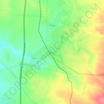
Naam: Topografische kaart Izra, hoogte, reliëf.
Gemiddelde hoogte: 583 m
Minimale hoogte: 553 m
Maximale hoogte: 626 m
Doe een donatie
Rust jezelf uit voor je volgende avontuur:
Als Amazon-partner verdient deze site een commissie op in aanmerking komende aankopen, zonder extra kosten voor jou.
Andere topografische kaarten
Klik op een kaart om zijn topografie, zijn hoogte en zijn reliëf te bekijken.