
Topografische kaart Glenwood Springs
Interactieve kaart
Klik op de kaart om de hoogte weer te geven.
Over deze kaart
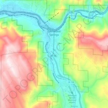
Naam: Topografische kaart Glenwood Springs, hoogte, reliëf.
Gemiddelde hoogte: 2.081 m
Minimale hoogte: 1.736 m
Maximale hoogte: 2.580 m
Local food production has seen a revival in recent years. While not as consistently fecund as the extensive agricultural and viticultural areas at lower altitude such as Palisade, most types of fruit and vegetable grow well in the light and soil if well watered. Stonefruit such as cherries, peaches, and plums, pomaceous fruit such as apples and pears, and grapes are suited to the climate and terrain.
Andere topografische kaarten
Klik op een kaart om zijn topografie, zijn hoogte en zijn reliëf te bekijken.
Battlement Mesa
United States > Colorado > Garfield County
Battlement Mesa, Garfield County, Colorado, 81635, United States
Gemiddelde hoogte: 1.806 m
Douglas Pass
United States > Colorado > Garfield County
Douglas Pass, Garfield County, Colorado, United States
Gemiddelde hoogte: 2.435 m
Carbondale
United States > Colorado > Garfield County
Carbondale, Garfield County, Colorado, United States
Gemiddelde hoogte: 1.919 m
New Castle
United States > Colorado > Garfield County
New Castle, Garfield County, Colorado, 81647, United States
Gemiddelde hoogte: 1.810 m
Rifle
United States > Colorado > Garfield County
Rifle, Garfield County, Colorado, 81650, United States
Gemiddelde hoogte: 1.731 m