
Topografische kaart Six Mile Lake Provincial Park
Interactieve kaart
Klik op de kaart om de hoogte weer te geven.
Over deze kaart
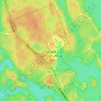
Naam: Topografische kaart Six Mile Lake Provincial Park, hoogte, reliëf.
Gemiddelde hoogte: 198 m
Minimale hoogte: 176 m
Maximale hoogte: 212 m
Andere topografische kaarten
Klik op een kaart om zijn topografie, zijn hoogte en zijn reliëf te bekijken.
Georgian Bay Islands National Park
Canada > Ontario > Georgian Bay
Georgian Bay Islands National Park, Georgian Bay, District Municipality of Muskoka, Muskoka District, Ontario, Canada
Gemiddelde hoogte: 179 m
Beausoleil Island
Canada > Ontario > Georgian Bay
Beausoleil Island, Georgian Bay, District Municipality of Muskoka, Muskoka District, Ontario, Canada
Gemiddelde hoogte: 180 m
Musquash River
Canada > Ontario > Georgian Bay
Musquash River, Georgian Bay, District Municipality of Muskoka, Muskoka District, Ontario, Canada
Gemiddelde hoogte: 211 m
Fairy Lake
Canada > Ontario > Georgian Bay
Fairy Lake, nice path, Georgian Bay, District Municipality of Muskoka, Muskoka District, Ontario, P0E 1E0, Canada
Gemiddelde hoogte: 182 m
Gibson River Provincial Park (NATURE RESERVE CLASS)
Canada > Ontario > Georgian Bay
Gibson River Provincial Park (NATURE RESERVE CLASS), Holiday Road, Georgian Bay, District Municipality of Muskoka, Muskoka District, Ontario, Canada
Gemiddelde hoogte: 203 m
Go Home River
Canada > Ontario > Georgian Bay
Go Home River, Georgian Bay, District Municipality of Muskoka, Muskoka District, Ontario, Canada
Gemiddelde hoogte: 192 m
Muskoka Landing Channel
Canada > Ontario > Georgian Bay
Muskoka Landing Channel, Georgian Bay, District Municipality of Muskoka, Muskoka District, Ontario, Canada
Gemiddelde hoogte: 177 m