
Doe een donatie
Rust jezelf uit voor je volgende avontuur:
Als Amazon-partner verdient deze site een commissie op in aanmerking komende aankopen, zonder extra kosten voor jou.
Topografische kaart Castro de Rei
Klik op de kaart om de hoogte weer te geven.
Doe een donatie
Rust jezelf uit voor je volgende avontuur:
Als Amazon-partner verdient deze site een commissie op in aanmerking komende aankopen, zonder extra kosten voor jou.
Castro de Rei
Castro de Rei is located in the comarca of the Terra Cha. This factor determines the most of their socioeconomic characteristics. Its average altitude is between 400 and 500 meters. In the east the terrain becomes more rugged due to its proximity to the eastern mountains. The elevation of the Montes dos Millares is 620 meters and the Pedras Albas has an elevation of 619 meters Pedras Albas. The Minho river and several of its tributaries irrigate the lands. The Minho runs through the municipality and derives secondary manifolds, which are Azúmara, the Lea, and Anllo. Climatically, Castro de Rei has a temperate climate with abundant rainfall in the winter months. The region is characterized by its plains and its vast wetlands, home to waterfowl and large communities of amphibians. Associated with these wetlands appears a landscape mosaic, ecologically rich with color and an ample variety of habitats: grasslands, crops, forests, heath and rushes. The functional organization of the territory follows a monocentric structure with three main comarcas: Vilalba, Guitiriz and Castro de Rei. Castro de Rei has three mountain ranges.
Doe een donatie
Rust jezelf uit voor je volgende avontuur:
Als Amazon-partner verdient deze site een commissie op in aanmerking komende aankopen, zonder extra kosten voor jou.
Over deze kaart
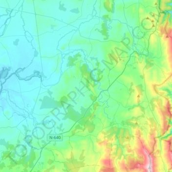
Naam: Topografische kaart Castro de Rei, hoogte, reliëf.
Locatie: Castro de Rei, Terra Chá, Lugo, Galicia, Spain (43.06769 -7.56114 43.28280 -7.34695)
Gemiddelde hoogte: 505 m
Minimale hoogte: 388 m
Maximale hoogte: 1.023 m
Doe een donatie
Rust jezelf uit voor je volgende avontuur:
Als Amazon-partner verdient deze site een commissie op in aanmerking komende aankopen, zonder extra kosten voor jou.
Andere topografische kaarten
Klik op een kaart om zijn topografie, zijn hoogte en zijn reliëf te bekijken.
Doe een donatie
Rust jezelf uit voor je volgende avontuur:
Als Amazon-partner verdient deze site een commissie op in aanmerking komende aankopen, zonder extra kosten voor jou.