
Topografische kaart Williston
Interactieve kaart
Klik op de kaart om de hoogte weer te geven.
Over deze kaart
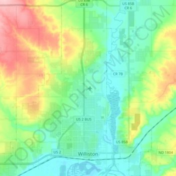
Naam: Topografische kaart Williston, hoogte, reliëf.
Locatie: Williston, Williams County, North Dakota, United States (48.13255 -103.71236 48.24476 -103.56103)
Gemiddelde hoogte: 603 m
Minimale hoogte: 559 m
Maximale hoogte: 699 m
Andere topografische kaarten
Klik op een kaart om zijn topografie, zijn hoogte en zijn reliëf te bekijken.
Tioga
United States > North Dakota > Williams County
Tioga, Williams County, North Dakota, 58852, United States
Gemiddelde hoogte: 692 m
Wheelock
United States > North Dakota > Williams County > Wheelock
Wheelock, Williams County, North Dakota, United States
Gemiddelde hoogte: 731 m
Williston
United States > North Dakota > Williams County > Williston
Williston, Williams County, North Dakota, 58801, United States
Gemiddelde hoogte: 631 m
Epping
United States > North Dakota > Williams County > Epping
Epping, Williams County, North Dakota, United States
Gemiddelde hoogte: 676 m