
Topografische kaart Stuyvesant Falls
Interactieve kaart
Klik op de kaart om de hoogte weer te geven.
Over deze kaart
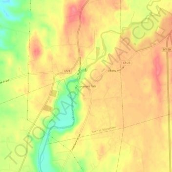
Naam: Topografische kaart Stuyvesant Falls, hoogte, reliëf.
Gemiddelde hoogte: 58 m
Minimale hoogte: 11 m
Maximale hoogte: 84 m
Andere topografische kaarten
Klik op een kaart om zijn topografie, zijn hoogte en zijn reliëf te bekijken.
Nutten Hook State Tidal Wetland
United States > New York > Columbia County > Town of Stuyvesant
Nutten Hook State Tidal Wetland, Town of Stuyvesant, Columbia County, New York, United States
Gemiddelde hoogte: 32 m
Newton Hook
United States > New York > Columbia County > Town of Stuyvesant
Newton Hook, Town of Stuyvesant, Columbia County, New York, 12173, United States
Gemiddelde hoogte: 26 m
Poolsburg
United States > New York > Columbia County > Town of Stuyvesant
Poolsburg, Town of Stuyvesant, Columbia County, New York, 12124, United States
Gemiddelde hoogte: 39 m