
Topografische kaart Windsor
Interactieve kaart
Klik op de kaart om de hoogte weer te geven.
Over deze kaart
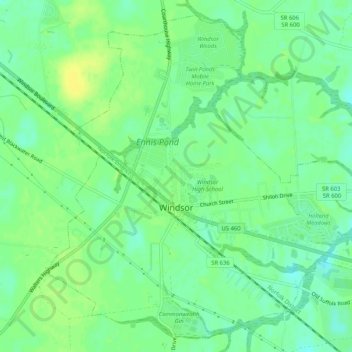
Naam: Topografische kaart Windsor, hoogte, reliëf.
Locatie: Windsor, Isle of Wight County, Virginia, United States (36.79315 -76.76356 36.83114 -76.71173)
Gemiddelde hoogte: 26 m
Minimale hoogte: 16 m
Maximale hoogte: 35 m
Andere topografische kaarten
Klik op een kaart om zijn topografie, zijn hoogte en zijn reliëf te bekijken.
Carrsville
United States > Virginia > Isle of Wight County
Carrsville, Isle of Wight County, Virginia, 23315, United States
Gemiddelde hoogte: 21 m
Whitley
United States > Virginia > Isle of Wight County
Whitley, Isle of Wight County, Virginia, United States
Gemiddelde hoogte: 24 m
Smithfield
United States > Virginia > Isle of Wight County
Smithfield, Isle of Wight County, Virginia, 23430, United States
Gemiddelde hoogte: 11 m
Smithfield
United States > Virginia > Isle of Wight County > Smithfield
Smithfield, Isle of Wight County, Virginia, 23430, United States
Gemiddelde hoogte: 11 m