
Topografische kaart Taüll
Interactieve kaart
Klik op de kaart om de hoogte weer te geven.
Taüll
Located at an altitude of 1,520 meters in the Sant Martí valley, a small valley in the Valley of Boí. The closest river is the Sant Martí river, Noguera de Tor affluent. A ravine splits the village in two districts: La Guinsa and Lo Barri. La Guinsa goes from the entrance of the village to the ravine, and Lo Barri goes from the ravine to the high part of the village.
Over deze kaart
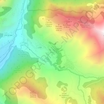
Naam: Topografische kaart Taüll, hoogte, reliëf.
Gemiddelde hoogte: 1.707 m
Minimale hoogte: 1.115 m
Maximale hoogte: 2.498 m