
Topografische kaart Mallorytown Landing
Interactieve kaart
Klik op de kaart om de hoogte weer te geven.
Over deze kaart
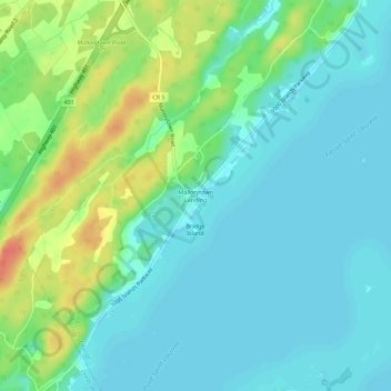
Naam: Topografische kaart Mallorytown Landing, hoogte, reliëf.
Gemiddelde hoogte: 86 m
Minimale hoogte: 72 m
Maximale hoogte: 121 m
Andere topografische kaarten
Klik op een kaart om zijn topografie, zijn hoogte en zijn reliëf te bekijken.
Mallorytown
Canada > Ontario > Leeds and Grenville Counties > Front of Yonge
Mallorytown, Front of Yonge, Leeds and Grenville Counties, Eastern Ontario, Ontario, K0E 1R0, Canada
Gemiddelde hoogte: 98 m