
Topografische kaart Bijie
Interactieve kaart
Klik op de kaart om de hoogte weer te geven.
Over deze kaart
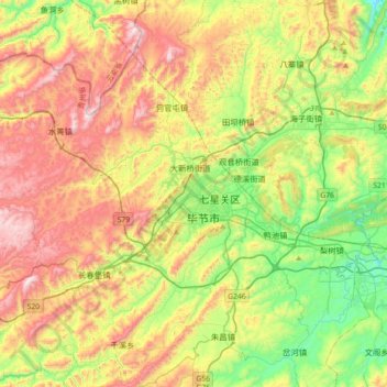
Naam: Topografische kaart Bijie, hoogte, reliëf.
Locatie: Bijie, Qixingguan, Bijie, Guizhou, 551700, China (27.12586 105.12660 27.44586 105.44660)
Gemiddelde hoogte: 1.651 m
Minimale hoogte: 1.320 m
Maximale hoogte: 2.158 m
Bijie borders Zunyi to the east, Anshun and Liupanshui to the south, Zhaotong and Qujing (Yunnan) to the west, and Luzhou (Sichuan) to the north. It spans latitude 26°21′−27°46′ N and longitude 105°36′−106°43′ E, and is marked heavily by the presence of the Wumeng Mountains (乌蒙山) as well as karst topography. The Wu, Beipan, and Chishui Rivers are the most important rivers that originate here. The highest elevation is Jiucaiping (韭菜坪), at 2,900.6 m (9,516 ft), on the border of Hezhang and Weining counties.
Andere topografische kaarten
Klik op een kaart om zijn topografie, zijn hoogte en zijn reliëf te bekijken.
Tianping
China > Guizhou > Yuping Dong Autonomous County
Tianping, Yuping Dong Autonomous County, Tongren, Guizhou, 558000, China
Gemiddelde hoogte: 593 m
Daxing
China > Guizhou > Songtao Miao Autonomous County > Daxing
Daxing, Songtao Miao Autonomous County, Tongren, Guizhou, 558000, China
Gemiddelde hoogte: 665 m
Daba
China > Guizhou > Zunyi City > Daba
Daba, Renhuai City, Zunyi City, Guizhou, China
Gemiddelde hoogte: 857 m
Shuiyao
China > Guizhou > Libo County > Shuiyao
Shuiyao, Libo County, Qiannan Buyei and Miao Autonomous Prefecture, Guizhou, 558000, China
Gemiddelde hoogte: 748 m
Xiazhai
China > Guizhou > Zunyi City > Xiazhai
Xiazhai, Bozhou District, Zunyi City, Guizhou, China
Gemiddelde hoogte: 807 m
Qianxinan Buyei and Miao Autonomous Prefecture
Qianxinan, Huangcao, Xingyi City, Qianxinan Buyei and Miao Autonomous Prefecture, Guizhou, China
Gemiddelde hoogte: 1.250 m