
Topografische kaart Big Arm
Interactieve kaart
Klik op de kaart om de hoogte weer te geven.
Over deze kaart
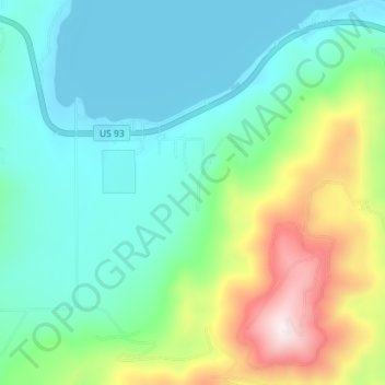
Naam: Topografische kaart Big Arm, hoogte, reliëf.
Locatie: Big Arm, Lake County, Montana, 59910, United States (47.76777 -114.30712 47.81343 -114.23608)
Gemiddelde hoogte: 1.064 m
Minimale hoogte: 880 m
Maximale hoogte: 1.577 m
Andere topografische kaarten
Klik op een kaart om zijn topografie, zijn hoogte en zijn reliëf te bekijken.
Charlo
United States > Montana > Lake County
Charlo, Lake County, Montana, United States
Gemiddelde hoogte: 895 m
Saint Ignatius
United States > Montana > Lake County
Saint Ignatius, Lake County, Montana, 59865, United States
Gemiddelde hoogte: 893 m
Flathead Lake
United States > Montana > Lake County
Flathead Lake, Lake County, Montana, United States
Gemiddelde hoogte: 1.168 m
Polson
United States > Montana > Lake County
Polson, Lake County, Montana, United States
Gemiddelde hoogte: 929 m
North Swan Valley Wildlife Management Area
United States > Montana > Lake County
North Swan Valley Wildlife Management Area, Lake County, Montana, United States
Gemiddelde hoogte: 1.231 m
Moore Lake
United States > Montana > Lake County
Moore Lake, Lake County, Montana, United States
Gemiddelde hoogte: 1.806 m
Estes Lake
United States > Montana > Lake County
Estes Lake, Lake County, Montana, United States
Gemiddelde hoogte: 1.068 m
Kicking Horse
United States > Montana > Lake County
Kicking Horse, Lake County, Montana, United States
Gemiddelde hoogte: 938 m
Mission Valley Historical Marker
United States > Montana > Lake County
Mission Valley Historical Marker, Lake County, Montana, 59865, United States
Gemiddelde hoogte: 909 m