
Doe een donatie
Rust jezelf uit voor je volgende avontuur:
Als Amazon-partner verdient deze site een commissie op in aanmerking komende aankopen, zonder extra kosten voor jou.
Topografische kaart Gold Hill
Klik op de kaart om de hoogte weer te geven.
Doe een donatie
Rust jezelf uit voor je volgende avontuur:
Als Amazon-partner verdient deze site een commissie op in aanmerking komende aankopen, zonder extra kosten voor jou.
Over deze kaart
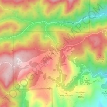
Naam: Topografische kaart Gold Hill, hoogte, reliëf.
Locatie: Gold Hill, Boulder County, Colorado, United States (40.04339 -105.43034 40.08339 -105.39034)
Gemiddelde hoogte: 2.440 m
Minimale hoogte: 2.143 m
Maximale hoogte: 2.675 m
Doe een donatie
Rust jezelf uit voor je volgende avontuur:
Als Amazon-partner verdient deze site een commissie op in aanmerking komende aankopen, zonder extra kosten voor jou.
Andere topografische kaarten
Klik op een kaart om zijn topografie, zijn hoogte en zijn reliëf te bekijken.
Boulder
United States > Colorado > Boulder County
Boulder is located at the base of the foothills of the Rocky Mountains, at an elevation of 5,430 feet (1,655 m) above sea level. Boulder is 25 miles (40 km) northwest of the Colorado state capital of Denver. It is home of the main campus of the University of Colorado, the state's largest university.
Gemiddelde hoogte: 1.800 m
Longmont
United States > Colorado > Boulder County
The elevation at City Hall is 4,978 feet (1,517 m) above sea level. St. Vrain Creek, a tributary of the South Platte River, flows through the city just south of the city center.
Gemiddelde hoogte: 1.537 m
Doe een donatie
Rust jezelf uit voor je volgende avontuur:
Als Amazon-partner verdient deze site een commissie op in aanmerking komende aankopen, zonder extra kosten voor jou.
Allenspark
United States > Colorado > Boulder County > Allenspark
Allenspark is located in northwest Boulder County within Roosevelt National Forest in the Front Range of the Colorado Rockies. The western edge of the community is the boundary of Rocky Mountain National Park. State Highway 7 passes through the community, leading north 15 miles (24 km) to Estes Park and east…
Gemiddelde hoogte: 2.874 m
Nederland
United States > Colorado > Boulder County
In 1873 the Caribou Mine, at an elevation of roughly 10,000 feet (3,000 m) and 6 miles (10 km) northwest of the town, was sold to the Mining Company Nederland from the Netherlands. The high elevation meant fierce winds and deep winter snow, so the new owners of the mine decided that it was beneficial to bring…
Gemiddelde hoogte: 2.578 m
Doe een donatie
Rust jezelf uit voor je volgende avontuur:
Als Amazon-partner verdient deze site een commissie op in aanmerking komende aankopen, zonder extra kosten voor jou.
Ward
United States > Colorado > Boulder County
Ward is a home rule municipality in Boulder County, Colorado, United States. The population was 128 at the 2020 census. The town is a former mining settlement founded in 1860 in the wake of the discovery of gold at nearby Gold Hill. Once one of the richest towns in the state during the Colorado Gold Rush, it…
Gemiddelde hoogte: 2.826 m
Doe een donatie
Rust jezelf uit voor je volgende avontuur:
Als Amazon-partner verdient deze site een commissie op in aanmerking komende aankopen, zonder extra kosten voor jou.
Gunbarrel
United States > Colorado > Boulder County > Gunbarrel
Gunbarrel is northeast of the city of Boulder proper, separated by a buffer area of private agricultural lands and publicly owned open space. The buffer areas provide over two miles (3 km) of separation over changing elevations.
Gemiddelde hoogte: 1.585 m
Doe een donatie
Rust jezelf uit voor je volgende avontuur:
Als Amazon-partner verdient deze site een commissie op in aanmerking komende aankopen, zonder extra kosten voor jou.
Boulder
United States > Colorado > Boulder County
Boulder is located at the base of the foothills of the Rocky Mountains, at an elevation of 5,430 feet (1,655 m) above sea level. The city is 25 miles (40 km) northwest of the Colorado state capital of Denver. Boulder is a college town, hosting the University of Colorado Boulder, the flagship and largest campus…
Gemiddelde hoogte: 1.800 m
Nederland
United States > Colorado > Boulder County
In 1873 the Caribou Mine, at an elevation of roughly 10,000 feet (3,000 m) and 6 miles (10 km) northwest of the town, was sold to the Mining Company Nederland from the Netherlands. The high elevation meant fierce winds and deep winter snow, so the new owners of the mine decided that it was beneficial to bring…
Gemiddelde hoogte: 2.578 m
Doe een donatie
Rust jezelf uit voor je volgende avontuur:
Als Amazon-partner verdient deze site een commissie op in aanmerking komende aankopen, zonder extra kosten voor jou.
South Boulder Canyon Ditch
United States > Colorado > Boulder County > Lafayette
Gemiddelde hoogte: 1.618 m
Doe een donatie
Rust jezelf uit voor je volgende avontuur:
Als Amazon-partner verdient deze site een commissie op in aanmerking komende aankopen, zonder extra kosten voor jou.
Allenspark
United States > Colorado > Boulder County
Allenspark is located in northwest Boulder County within Roosevelt National Forest in the Front Range of the Colorado Rockies. The western edge of the community is the boundary of Rocky Mountain National Park. State Highway 7 passes through the community, leading north 15 miles (24 km) to Estes Park and east…
Gemiddelde hoogte: 2.874 m
Boulder
United States > Colorado > Boulder County
Boulder is located at the base of the foothills of the Rocky Mountains, at an elevation of 5,430 feet (1,655 m) above sea level. The city is 25 miles (40 km) northwest of the Colorado state capital of Denver. Boulder is a college town, hosting the University of Colorado Boulder, the flagship and largest campus…
Gemiddelde hoogte: 1.800 m
Ward
United States > Colorado > Boulder County
Ward is a home rule municipality in Boulder County, Colorado, United States. The population was 128 at the 2020 census. The town is a former mining settlement founded in 1860 in the wake of the discovery of gold at nearby Gold Hill. Once one of the richest towns in the state during the Colorado Gold Rush, it…
Gemiddelde hoogte: 2.826 m
Doe een donatie
Rust jezelf uit voor je volgende avontuur:
Als Amazon-partner verdient deze site een commissie op in aanmerking komende aankopen, zonder extra kosten voor jou.
Boulder
United States > Colorado > Boulder County
Boulder is located at the base of the foothills of the Rocky Mountains, at an elevation of 5,430 feet (1,655 m) above sea level. The city is 25 miles (40 km) northwest of the Colorado state capital of Denver. Boulder is a college town, hosting the University of Colorado Boulder, the flagship and largest campus…
Gemiddelde hoogte: 1.800 m
Longmont
United States > Colorado > Boulder County
The elevation at City Hall is 4,978 feet (1,517 m) above sea level. St. Vrain Creek, a tributary of the South Platte River, flows through the city just south of the city center.
Gemiddelde hoogte: 1.537 m
Boulder
United States > Colorado > Boulder County
Boulder is located at the base of the foothills of the Rocky Mountains, at an elevation of 5,430 feet (1,655 m) above sea level. The city is 25 miles (40 km) northwest of the Colorado state capital of Denver. Boulder is a college town, hosting the largest campus of the University of Colorado (the state's…
Gemiddelde hoogte: 1.800 m
Doe een donatie
Rust jezelf uit voor je volgende avontuur:
Als Amazon-partner verdient deze site een commissie op in aanmerking komende aankopen, zonder extra kosten voor jou.
Longmont
United States > Colorado > Boulder County
The elevation at City Hall is 4,978 feet (1,517 m) above sea level. St. Vrain Creek, a tributary of the South Platte River, flows through the city just south of the city center.
Gemiddelde hoogte: 1.534 m
Nederland
United States > Colorado > Boulder County
In 1873 the Caribou Mine, at an elevation of roughly 10,000 feet (3,000 m) and 6 miles (10 km) northwest of the town, was sold to the Mining Company Nederland from the Netherlands. The high elevation meant fierce winds and deep winter snow, so the new owners of the mine decided that it was beneficial to bring…
Gemiddelde hoogte: 2.578 m
National Center for Atmospheric Research
United States > Colorado > Boulder County > Boulder
Gemiddelde hoogte: 1.816 m
Doe een donatie
Rust jezelf uit voor je volgende avontuur:
Als Amazon-partner verdient deze site een commissie op in aanmerking komende aankopen, zonder extra kosten voor jou.
Sombrero Marsh
United States > Colorado > Boulder County > Boulder Junction
Gemiddelde hoogte: 1.605 m