
Topografische kaart Fatu Hiva
Interactieve kaart
Klik op de kaart om de hoogte weer te geven.
Over deze kaart
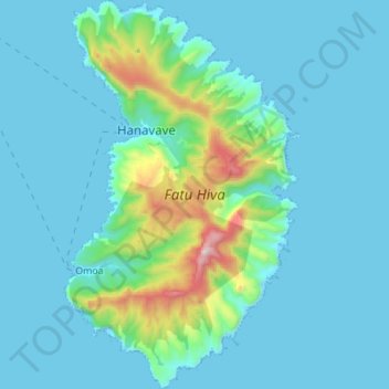
Naam: Topografische kaart Fatu Hiva, hoogte, reliëf.
Gemiddelde hoogte: 129 m
Minimale hoogte: -1 m
Maximale hoogte: 1.019 m
The mountain rainforest still harbours some endemic plants, such as Ochrosia fatuhivensis and Melicope fatuhivensis (syn. Pelea fatuhivensis), a tree of the Rutaceae family which may already be extinct. Pterophylla tremuloides is an endemic shrub which grows in low ridge top and cliff shrubland with Metrosideros, Dicranopteris and Lycopodium from 700 to 850 metres elevation. A systematic study of the flora with the support of the Smithsonian Institution in 1988 revealed the number of 175 native, 21 endemic, and 136 anthropochoric plants.