
Topografische kaart Bulle
Interactieve kaart
Klik op de kaart om de hoogte weer te geven.
Bulle
The municipality is the capital of the Gruyère district. It is located on a hill at an elevation of 770 meters (2,530 ft) above the left side of the Trême river.
Over deze kaart
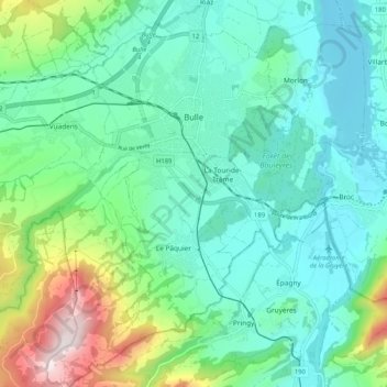
Naam: Topografische kaart Bulle, hoogte, reliëf.
Locatie: Bulle, Gruyère District, Fribourg, Switzerland (46.56952 6.99339 46.64054 7.09527)
Gemiddelde hoogte: 834 m
Minimale hoogte: 665 m
Maximale hoogte: 1.383 m