
Topografische kaart Arnoldsburg
Interactieve kaart
Klik op de kaart om de hoogte weer te geven.
Over deze kaart
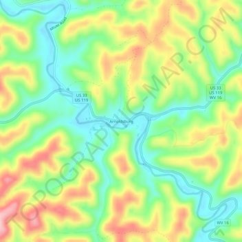
Naam: Topografische kaart Arnoldsburg, hoogte, reliëf.
Gemiddelde hoogte: 287 m
Minimale hoogte: 213 m
Maximale hoogte: 389 m
Arnoldsburg (also Arnoldsburgh) is an unincorporated community in Calhoun County, West Virginia, United States. It lies along U.S. Route 33 at the point where West Virginia Route 16 heads southward; it is several miles south of the county seat of Grantsville. Its elevation is 738 feet (225 m). The West Fork Little Kanawha River flows through the community. It has a post office with the ZIP code 25234.
Andere topografische kaarten
Klik op een kaart om zijn topografie, zijn hoogte en zijn reliëf te bekijken.
Mount Zion
United States > West Virginia > Calhoun County
Mount Zion, Calhoun County, West Virginia, 26151, United States
Gemiddelde hoogte: 312 m
Orma
United States > West Virginia > Calhoun County
Orma, Calhoun County, West Virginia, 25268, United States
Gemiddelde hoogte: 299 m
Millstone
United States > West Virginia > Calhoun County
Millstone, Calhoun County, West Virginia, 25261, United States
Gemiddelde hoogte: 310 m
Chloe
United States > West Virginia > Calhoun County
Chloe, Calhoun County, West Virginia, 25235, United States
Gemiddelde hoogte: 314 m
Bigbend
United States > West Virginia > Calhoun County
Bigbend, Calhoun County, West Virginia, 26152, United States
Gemiddelde hoogte: 270 m
Purdy
United States > West Virginia > Calhoun County > Purdy
Purdy, Calhoun County, West Virginia, 26136, United States
Gemiddelde hoogte: 263 m
Ayers
United States > West Virginia > Calhoun County
Ayers, Calhoun County, West Virginia, 26136, United States
Gemiddelde hoogte: 289 m
Grantsville
United States > West Virginia > Calhoun County
Grantsville, Calhoun County, West Virginia, 26147, United States
Gemiddelde hoogte: 261 m