
Topografische kaart Goatstown
Interactieve kaart
Klik op de kaart om de hoogte weer te geven.
Over deze kaart
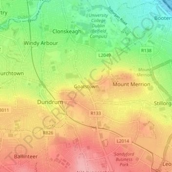
Naam: Topografische kaart Goatstown, hoogte, reliëf.
Gemiddelde hoogte: 57 m
Minimale hoogte: -1 m
Maximale hoogte: 111 m
Andere topografische kaarten
Klik op een kaart om zijn topografie, zijn hoogte en zijn reliëf te bekijken.
Knockanteedan
Knockanteedan, Glassamucky, Bohernabreena DED 1986, South Dublin, County Dublin, Leinster, D24 T651, Irland
Gemiddelde hoogte: 243 m
Howth
Howth, Fingal, County Dublin, Leinster, D13 V2F9, Irland
Gemiddelde hoogte: 8 m